Showing posts with label fog. Show all posts

25 August 2016

Pocket Technology

I have been quite slow in adopting mobile technology. Until two years ago I was using a dumb-phone which I think it was the right thing to do. However, In the last couple of years the smartphones matured, became more reliable and a lot cheaper.

Nowadays I carry a smartphone on all of my runs. Currently I use a rather low cost Motorola G3. I record the track using the GPS receiver of the phone. It is still less accurate than my 9 years old GPS receiver, but just good enough. It is water resistant (up to a point), good enough so I do not worry in the rain,

The phone also has a camera which is quite impressive, better that I would have expect. It also has an auto HDR mode that is doing a very good job! At 28mm focal length equivalent, it is sharper than my older Nikon AW-110 pocket camera! At longer focal lengths the Nikon lens gets sharper while the camera does "zoom" digitally, producing bad quality images.

Nevertheless, it is great to have this camera in my pocket all the time. Almost every run I stop along the way and take a few shots. Here are three shots from the last days. At a closer inspection one can see the imperfections of a phone camera lens and small sensor, but overall, the images are very good, certainly great for on-screen display.

Going up on Piatra Mare Mountain .Auto HDR 

Lost in the fog

Early morning in Poiana Brasov. Auto HDR

29 November 2014

An icy day!

After a few beautiful  sunny and chilly winter days that followed the snow fall of last weekend, I had big plans for today: first ski tour of the season! Unfortunately, on Friday afternoon it started to rain... This morning (Saturday) it was still raining. It was clear that the weather was too wet for ski touring. Moreover, a quick look on the webcams confirmed my fears that high in the mountains it was also raining as the air higher in the altitude was warmer than in the city.

In the city was raining, but the temperature was below 0C. So everything got covered in a thick layer of ice! The view from my balcony did not look too inviting.


Later, towards the noon the rain stopped so I quickly got equipped for trail running. The most important piece of the equipment were the running ice crampons! Out of the city, the forest road  was covered in a thick and and rock solid layer of ice! Without the crampons it would have been impossible to walk! The icy road lasted for about 5 km. Around 1000m altitude in Poiana Brasov it was already warmer, just above freezing so there were only a few icy patches on the route. At some point I could see the sun through the foggy air so I decided to go a bit higher than the planned route. I soon got above the sea of low clouds and almost immediately the temperature rose to about +7C! There were a few skiers. The slopes on the high part of the mountain looked quite good, but lower, the ski slope was interrupted in a few places.

A higher layer of clouds confirmed the weather report that more rain, and then snow is on the way. I snapped a few photos with my crappy phone camera and started to run downhill, back to the city. Below 1000m altitude the temperature was still below freezing. I chose a different route downhill, along the old Poiana Road. Here, half of the road width was covered in a thick layer of leaves so the ice was not solid like on the uphill route, meaning that I could run downhill with confidence.
Now, in the evening, as I write it, the rain that started again tries to turn into snow, a sign that colder air invaded the higher altitudes... so that first ski touring trip of the season might happen very soon!


01 June 2014

Hit The Top. 2014 Edition

The Logo from the event home page

2014 Edition in a few words:
  • Tough, wet, wet, wet, bloody wet and cold... 
  • But what a great day!

This was the fourth Hit The Top edition, my third time here and my second time as a racer. It is a special race. It is short but tough, with more than 1600m of accumulated altitude gain in just a few kilometers. The number of the participants is kept at under 100 and the level of the runners is very high, including a few professional athletes.

I participated in the race in 2012, when it was one of my first trail running races. At that time the race was shorter; the return point was on Scara Peak at 2308m altitude. Last year the race route was extended by two more kilometers until Omu Peak (2505m), the highest peak of Bucegi Mountains and I decided not to race, but instead to run along the route and take photos; Here is my last year's race report with photos and GPS track. This year I had to compete again; I had to do the complete race to Omu Peak!

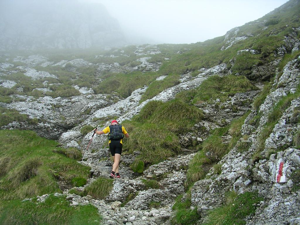
I tried to prepare well for this race. I accumulated many meters of altitude gain during my training runs the weeks before, followed by a few days of resting before the race. However, nothing prepared me for the wet weather on the race day. I often run in the rain, but on bad weather I keep away from the mountain heights. Yesterday, during the race, I went up all the way to 2500 meters altitude on Omu Peak, in a weather I would never plan myself such a trip!

Actually the weather during the race was better than the forecast a few days before. It rained all the time and it was foggy, but otherwise the weather was stable. The wind on to mountain tops was rather weak but not at all pleasant on the wet clothes. There was no thick fog so I had no orientation problems. A volunteer, on the rather flat Scara Peak, where fog could cause orientation issues, made sure that the runners took the right path. Also the abundant snow that fell in April was mostly gone. Just below Omu Peak there were larger patches of snow.

The start of the race was at 9:15 AM. I started the climb at a comfortable pace and all the way up to Omu Peak I tried not to run too fast and to conserve energy. I did not want to exhaust myself in that cold wet weather, especially high on the mountain. 30 minutes after the start my clothes were already quite wet. I felt like in the middle of a soaked sponge and I knew that it will only get wetter... . My biggest worry was the wind. I was prepared to abandon the race if  the wind would get too strong high on the ridges. Hypothermia can be a serious issue high on the mountains. Luckily the weather was OK high there. The wind, mixed with raindrops and even a few snow flakes was constantly blowing from the north Luckily, most of the trail from below Scara Peak until Omu is on the southern side of the ridge so it was rather sheltered from the wind.

My choice of clothing was not too bad. I wore a thin woolen merino shirt and a thin runner wind-stopper jacket on top of it. The wool got soaked in water and sweat. Well, anything would have got soaked in that weather, but the wool retains the heat better than other fabrics when wet. I had gloves that got so wet that I would squeeze the water out of them every two minutes just by clenching my fists. However, even so wet, they protected my hands from the cold wind so my hands stayed warm. I had long running trousers - I chose thicker warmer ones. Maybe not the best choice as they also got soaked in water, but at least they kept me warm. I heard from other runners that thin trousers were not enough. As head gear I had a thin running cap and a headband. I also had a thicker winter hat with me. I did not use it but it was good to feel it in my pocket!

After the race, when I have weighted my wet equipment I realized that I was carrying more than a liter of water in my clothes and shoes... maybe close to two liters... Speaking of excess weight, half way up the mountain I realized that I could have run without my bottle belt. The water offered by volunteers at the three hydration points along the route would have been enough in this cold and wet weather. What a difference from 2012, when the race was on a hot day and the one liter I have carried plus the water from the hydration points were hardly enough to extinguish my thirst!

I have been the 29th runner to reach Omu Peak. I did not stop there so I left behind a few runners, but not for too long as I am a too cautious downhill runner. I felt well and warm enough to skip the hot tea offered by the race organizers at Omu Peak. I know that other racers, that were not so well equipped for the cold weather, dreamt about that warm tea during all the way up!

First part of the descent went quickly for me. I tried to run as much as I could on the snow patches by the trail. The snow was quite wet and soft, but hard enough so I would not sink too much and could safely run fast with long steps. It was better than on the trail which consisted of a mixture of melting snow, water, mud and rocks... Soon, below Scara Peak the trail becomes steeper. From here until the end of the race I was overtaken by many other runners on each steep section of the route. I was joking that if the descent was longer all racers would have overtook me. But I preferred to be on the safe side. Lower in the forest the steep trail was extremely muddy and slippery and again, I did it at a very slow pace. Some other runners asked me if I was OK while they overtook me... I must have look quite hopeless. But I did not care. I then quickly ran the last 3 kilometers of the race on the forest road and finished the race on the 35th place, happily and in one piece! I can proudly say that I had no falls during the race.

[Added a day later] Now that the official results are ready I can see that I had the 45th descent time... Somewhere in the middle... Not so catastrophic after all, but it is the worse descent time of the top 40 runners.

After the race, the organizer offered us a nice warm soup and a tasty desert at a local restaurant in Bran. How nice to have a hot soup after spending so many hours in the cold wet rain. Time to socialize with the other runners before the awards ceremony.

All in all it was a great experience! The difficult weather and trail conditions made it an unforgettable race. The volunteers and mountain rescue members had a much tougher time than the runners. While we were running, keeping ourselves warm, they had to endure the rain and wind, up on the mountain heights for almost 10 hours! A big thank you to all of them and to all organizers of this event!

Let's hit the top again in 2015!


27 December 2013

Hochnebel

Hochnebel - a German word used in the Alps that describes the "sea of clouds" weather phenomenon. It simply means high fog. Usually, the phenomenon appears in the cold months of the year and is caused by low lying stratus clouds. At the extreme, the low-lying stratus clouds can last for many weeks and they can cover vast areas like whole countries leaving just the mountain peaks above in the sunshine. Below the clouds there is the most depressing possible weather: a monotone cold humid grey... Above the clouds.. well, there is the most glorious weather: warm and bright, above a sea of clouds that stretches to the horizon.

In the Alps, the altitude of the clouds' upper limit is mentioned on the weather-reports so people can plan their weekend trips above the clouds. Not so in Romania where I live. Most people here are not aware that a few hundred meters above the miserable weather the sky can be blue and the sun shining!

In cities, under the sea of clouds, the air also gets very polluted. The static weather means that there is no wind to sweep away the fumes from the cars, industry and buildings heating. The cold air only makes it worse as more fuel is burned for heating.

So during the cold months of the year, when the weather is grey, if you live close to the mountains, check the web-cams on the mountains. You might have a surprise!

This year, the winter in Brasov started with 3 weeks of Hochnebel. So whenever possible, I chose my trail running routes so I would reach the sunshine above the clouds. What a joy getting out of the fog into the sunshine... and what a shock descending back to the city through the cold humid fog...

Here are a few photos with the sea of clouds phenomenon in the mountains around Brasov, taken during the last years:

18 September 2013

Ciucas Trail Marathon 2013

This Saturday I ran my fourth full marathon. I participated in the Marathon Race of the Ciucas Trail event. The event has three races. A half-marathon, a marathon and an 100km individual ultra-marathon. Last year I ran the half-marathon so this time and I wanted to do the full marathon race.

One month before the event I did a reconnaissance run on the marathon route; an illustrated description of the route can be found in an older post. Knowing the route meant that I did not have any orientation issues during the race. The trails were very well marked, except a few key crossroad points that could have been better signaled. Unfortunately a few of the best runners got lost and ended up doing a different route... not necessarily easier.

The weather was cold, wet and quite windy on the exposed mountain top. When I left Brasov in the morning it was raining heavily and I was mentally preparing myself for running in the cold pouring rain. Luckily the rain gradually eased and eventually stopped just before the race start! I ran with a thin merino wool shirt. I also had my running jacket with me and used it on the windy sections. At the end it wasn't that cold and the woolen shirt was a bit too much and got quite wet, but without causing too much discomfort.
On my way to Ciucas peak  - photo by Camelia Varsescu
Once more, I ran the race without any watch or GPS device. I really like racing this way. I study the map before the race and I make a race plan. During the race I always have a good idea where I am and how to manage my energy. I also tried to run my own race, not paying too much attention to the other competitors. I did not want to get exhausted and also did not want to hammer my knees on the downhills. At the beginning of the race, in the forest, the trails were a bit muddy. However, much of the route had really good running conditions. The wet trails were better than during the reconnaissance run when they were very dry and dusty.

After the first 10 kilometers my place in the race stabilized. I am quite good on uphills so I almost caught up with a few runners on Ciucas top. However, soon, on the downhill they disappeared in the distance ahead of me as I was carefully running downhill. During the downhill I was expecting to be overtaken by several runners, but nobody did. Later I learned that just after I started my descent from the peak, it was covered in a thick fog so the next runners got lost in the fog for about 10 minutes. Actually after passing by Ciucas Hut one runner (Florin Simion) overtook me. He was ahead of me until the hut, but stopped there, while I decided to skip the hut stop on my way down to the finish line.

I finished with quite a good time: 4h52. Almost the same time as on the reconnaissance run, but that time I skipped a 5.5km section of the route that also included a long 300m elevation gain ascent. I could probably be 10 minutes quicker if I would have run faster downhill. I preferred however to be careful with my knees and to avoid slipping on the muddy sections. I managed to finish the 13th of the 168 competitors, and the 7th in my age category. Not a bad result, but many good runners were either absent from this event, or were running the ultra or the half marathon races.

I want to thank the organizers and the volunteers for the effort they spent to organize this event. It is not an easy task to manage three different races in the same day. The bad weather made it more difficult. I also know that they had some serious unexpected issues that made organizing the event even harder.

I am now concentrating on my last marathon of 2013. The famous and spectacular Piatra Craiului Marathon. See you there!

17 June 2013

Sky Running in Bucegi Mountains

June 16. Finally a dry day, after about 3 weeks of rainy, wet and cool weather... Again the mountains are shining in the sun light and I could not resist their call! 
Together with Andrei, we are going to do a second team training for Marathon 7500. This time, our route in Bucegi Mountains precisely follows the race route. Our route for today is a bit shorter in distance than half of the hobby race route. However it has more than half of the elevation gain, and covers many of the technical sections of the race route.


We start in the morning from Gura Diham, 4km from Busteni, at the end point on an unpaved road. This is a popular picnic area but we aim just a little bit higher... Omu Peak, the highest point on our route, and also the highest peak of Bucegi is towering above us, 1500m higher.


First part of the route, until Poiana Izvoarelor Mountain Chalet is entirely in the forest. We gain 450m in altitude. At Poiana Izvoarelor as we get out of the woods we are greeted with a nice view towards Costila peak with its abrupt rocky walls. From here, until the base of the Bucsoiu ridge, the route follows a watershed ridge. To the south the water flows towards Prahova river; to the norh to Barsa river and Tara Barsel (Burzenland). We are in fact on the old border between Romanian Kingdom and Austro-Hungarian Empire.


After a short section of flat trail we arrive on the bottom of the Bucegi northern abrupt. From here to the top we have a climb of about 1000m. We pass Bucsoiu valley. A beautiful memorial bench reminds us that the mountains can be a dangerous place on bad weather. It is not very uncommon that summer storms cause flash-floods that sometimes take hikers by surprise. A year ago, a young hiker was killed by a flash-food on this valley .


As we get out of the forest the slope becomes steeper. As we are climbing, the fog starts to engulf the mountain. It is not unpleasant as the fog is not too thick and keeps the air temperature cool, just right for our quick uphill pace.


The middle section of the climb has a few steeper sections. A couple of chains on the most abrupt section eases the climb.


As we approach Bucsoiu peak, a break in the clouds offers us some stunning views towards Malaiesti Valley. Down in the valley we spot Malaiesti Mountain hut.


The fog engulfs us again. As we are on the exposed main ridge of Bucsoiu it gets quite windy. Luckily the wind helps our climb by pushing us from behind.


 We follow the trail through the fog and pass Bucsoiu peak (2492m). The GPS reading confirms that we are on the top. A rather long descent from the top and then again an ascent. It should be the last one as I know that we are very close to Omu peak. A signpost confirms it! We are just 300m away from Omu Peak! A quick sprint and we are on the top!


 Omu hut is just on south-eastern side of the large cliff of Omu peak. We go in and have a 30 minutes  break, relaxing around several cups of hot tea - tasty tea made from mountain plants. Before leaving I replenish my water bottle with tea.


 Of course, we cannot leave the top without taking the conventional "Iwas here" photo...


From here we have a long downhill on Cerbului Valley. As soon as we start descending, the sun rays start to break more and more through the clouds.


I am surprised how well I feel running on this trail! In my light running gear it is different and far better than in my memories! Last time I walked downhill the whole valley two years ago. That was before I started trail running; I had heavy stiff mountain boots and a larger back-pack. I now realize how much more agile I am with trail running gear and how much more enjoyable it is!


The sunny weather offers us stunning views of Cerbului Valley! As we 'fly' downhill, the changing light and the angles stop us often to take photos.


We eventually enter again the forest. The descent is almost over.


We reach Poiana Costilei (poiana = meadow) and are rewarded by wonderful views towards the Bucegi abrupt. It is getting hot, but we are close to the end of the route.


From Poiana Costilei, a rather long and boring descent through the forest awaits us. 300m below we reach the valley floor and the unpaved road to Gura Diham. We run one more kilometer along the road until the car park. Luckily the road is wet from the yesterday's rain so the occasional passing cars do not raise any dust.

I enjoyed very much this run! We kept a comfortable pace as there was no point to exhaust ourselves. We did it in about 4h45, including all the breaks. I am pleased. Even in the race this would not be a bad time. We are now looking forward to participating in Marathon 7500 race... This year we are going to run  the shorter hobby race. I just hope that the weather will be as nice as it was today.