17 June 2013

Sky Running in Bucegi Mountains

June 16. Finally a dry day, after about 3 weeks of rainy, wet and cool weather... Again the mountains are shining in the sun light and I could not resist their call! 
Together with Andrei, we are going to do a second team training for Marathon 7500. This time, our route in Bucegi Mountains precisely follows the race route. Our route for today is a bit shorter in distance than half of the hobby race route. However it has more than half of the elevation gain, and covers many of the technical sections of the race route.


We start in the morning from Gura Diham, 4km from Busteni, at the end point on an unpaved road. This is a popular picnic area but we aim just a little bit higher... Omu Peak, the highest point on our route, and also the highest peak of Bucegi is towering above us, 1500m higher.


First part of the route, until Poiana Izvoarelor Mountain Chalet is entirely in the forest. We gain 450m in altitude. At Poiana Izvoarelor as we get out of the woods we are greeted with a nice view towards Costila peak with its abrupt rocky walls. From here, until the base of the Bucsoiu ridge, the route follows a watershed ridge. To the south the water flows towards Prahova river; to the norh to Barsa river and Tara Barsel (Burzenland). We are in fact on the old border between Romanian Kingdom and Austro-Hungarian Empire.


After a short section of flat trail we arrive on the bottom of the Bucegi northern abrupt. From here to the top we have a climb of about 1000m. We pass Bucsoiu valley. A beautiful memorial bench reminds us that the mountains can be a dangerous place on bad weather. It is not very uncommon that summer storms cause flash-floods that sometimes take hikers by surprise. A year ago, a young hiker was killed by a flash-food on this valley .


As we get out of the forest the slope becomes steeper. As we are climbing, the fog starts to engulf the mountain. It is not unpleasant as the fog is not too thick and keeps the air temperature cool, just right for our quick uphill pace.


The middle section of the climb has a few steeper sections. A couple of chains on the most abrupt section eases the climb.


As we approach Bucsoiu peak, a break in the clouds offers us some stunning views towards Malaiesti Valley. Down in the valley we spot Malaiesti Mountain hut.


The fog engulfs us again. As we are on the exposed main ridge of Bucsoiu it gets quite windy. Luckily the wind helps our climb by pushing us from behind.


 We follow the trail through the fog and pass Bucsoiu peak (2492m). The GPS reading confirms that we are on the top. A rather long descent from the top and then again an ascent. It should be the last one as I know that we are very close to Omu peak. A signpost confirms it! We are just 300m away from Omu Peak! A quick sprint and we are on the top!


 Omu hut is just on south-eastern side of the large cliff of Omu peak. We go in and have a 30 minutes  break, relaxing around several cups of hot tea - tasty tea made from mountain plants. Before leaving I replenish my water bottle with tea.


 Of course, we cannot leave the top without taking the conventional "Iwas here" photo...


From here we have a long downhill on Cerbului Valley. As soon as we start descending, the sun rays start to break more and more through the clouds.


I am surprised how well I feel running on this trail! In my light running gear it is different and far better than in my memories! Last time I walked downhill the whole valley two years ago. That was before I started trail running; I had heavy stiff mountain boots and a larger back-pack. I now realize how much more agile I am with trail running gear and how much more enjoyable it is!


The sunny weather offers us stunning views of Cerbului Valley! As we 'fly' downhill, the changing light and the angles stop us often to take photos.


We eventually enter again the forest. The descent is almost over.


We reach Poiana Costilei (poiana = meadow) and are rewarded by wonderful views towards the Bucegi abrupt. It is getting hot, but we are close to the end of the route.


From Poiana Costilei, a rather long and boring descent through the forest awaits us. 300m below we reach the valley floor and the unpaved road to Gura Diham. We run one more kilometer along the road until the car park. Luckily the road is wet from the yesterday's rain so the occasional passing cars do not raise any dust.

I enjoyed very much this run! We kept a comfortable pace as there was no point to exhaust ourselves. We did it in about 4h45, including all the breaks. I am pleased. Even in the race this would not be a bad time. We are now looking forward to participating in Marathon 7500 race... This year we are going to run  the shorter hobby race. I just hope that the weather will be as nice as it was today.

09 June 2013

Piatra Mare. Running for 4 hours in the rain

8 June 2013. St. Medardus Day. There is a saying in my city of Brasov (and not only here) that if it rains on this day, it will rain every day for the next 40 days. There is some truth in this saying, as the month of June is often quite wet in this mountainous corner of Transylvania. In any case, last two weeks were very wet and quite cool in Brasov - it rained almost every day. But after the unusually dry and very warm month of May the rains were more than welcomed! 

For this day, I planned to do a training run with Andrei in Piatra Mare massif.  We plan to run together as a team this July in Bucegi Marathon 7500 Hobby race. Even the shorter Hobby race is a tough one. For safety, because it takes place in high and steep mountains, this race is run in teams of two runners. 

Due to the very wet weather we almost canceled the tour. Normally, on rainy days I stay closer to home, but this time we decided to ignore the weather, stick to the plan and do a tour that we will remember. At the end, running in the rain was a very good way to prepare for the Maraton 7500 race as the wet trails were tougher and more interesting.

The good thing was that almost no wind was forecasted for the day - also no thunder storms. So there was no danger to go up the mountain. Piatra Mare is not a very high mountain, a good choice for a day like this. It is covered in thick woods, except the higher part which has a small treeless and more exposed plateau.

The route we chose followed the main ridge of the mountain from the south to the north. We started the climb by DN1 main road, going up on Tamina forest road. The starting point can be reached by train. Timisu de Sus train stop is not far. But we just took a taxi from Brasov. Andrei left his car lower on Timis valley at Dambul Morii (also by DN1 road). Our route ended there.


At the beginning the route follows the Tamina forest road for about 5km. It has a gentle slope suitable for running. After 3-4km, the road passes very close to the Tamina waterfall. It is a spectacular waterfall in a narrow limestone gorge. We did not visit it as we were already wet enough from the rain. On a hot summer day it would have been a different story...

The track presented below is recorded last year on an hiking tour, but the route is identical to the one described in this post, except the last two kilometers.
After a little more than 4km on the forest road, in a small forest clearing we reached Tamina Chalet. I have no idea who owns it. It probably belongs to the Forest Authority. There is an abundant water spring here. From here the route leaves the forest road and continues with a steep long climb. Today, on rain, it was quite muddy and slippery.


After a while the slope eases and it also becomes less muddy, continuing the ascent through the pine forest on Galbeaza mountain flank of Piatra Mare.


Wet forest, wet and misty camera lens...
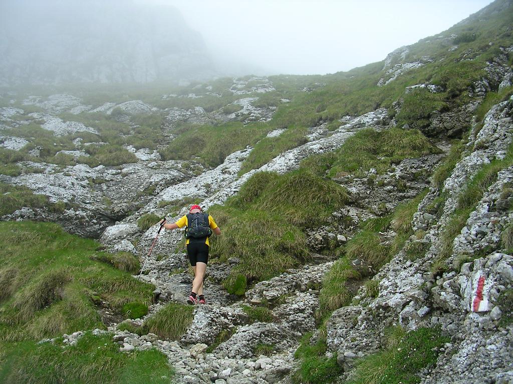
At about 1600m the trail comes out of the forest. From here to the top it follows the treeless high pastures. On a clear day it offers stunning views towards the surrounding mountains... Today we were happy that the fog is not thick and we can easily follow the path.


We pass by a shepherd hut. There are many cows around on the pastures and a few donkeys and horses by the hut. Luckily there are no dogs in sight. The weather must be too bad even for a dog...


Higher we reach the small top plateau and the slope eases even more so we can run again. Shortly we reach the summit at about 1800m altitude. The top is very close now.


A short run and we reach the summit.


No panoramas this time, yet the fog gives an mysterious atmosphere to the place.


I have time to take a quick self-portrait and then start running downhill. It is quite cold here as the peak is quite exposed. There is only a slight breeze but it feels cold as my t-shirt is soaked with rain water.

A bit lower from the peak we meet a beautiful patch of flowering rhododendron bushes. Time to stop for a couple of minutes and take a few photos.


We continue to run downhill towards Piatra Mare Mountain Hut. As we feel quite warm we decide not to go inside for a cup of tea. I am afraid that if we stop it will be very hard to go out and start running again through the rain. By the hut I take a photo of a shepherd that overlooks a flock of sheep. A classical shepherd pose!


Again, no shepherd dogs in sight!

Lower on the mountain it becomes warmer and the rain seems to stop. We decide to take the longer route to Dambul Morii, by making a detour to Bunloc hill. The trail to Bunloc is not very popular and passes through some quite wild forest. It is not an easy route as it goes up and down several times. We run very slowly as the trail is slippery, soaked in water and it often gets quite rocky and technical.


After we just pass the the entrance to "Pestera de Gheata" (The Ice Cave) we find right on the path a baby deer. It looks week. It has no wound signs but it may be sick. I have to admit that I do not know much about deer - I cannot even tell how old it is. We make a few phone calls to ask for advice. We follow the advice and the common sense. We do not touch it and we leave it there. Better not to interfere with nature. Hopefully its mother is close.


As the trail descends towards Bunloc we come in and out fog. The forest looks amazing, with fresh green in the foreground and ghostly three silhouettes further in the fog.


I stop many times and take photos of the forest. At some point my old camera succumbs to the rain. It is not an waterproof camera. It is my oldest camera, an 9 years old Nikon Coopix. It only has 3 mega-pixels but I still think that it takes much better photos than most mobile phone cameras. It is small and I ran all the way with it in my hand. Slowly, as the water makes its way inside the camera the buttons stop working one by one. Luckily the shutter button is the last one that stops working. The photo below is the last one I could take... The foggy lens gives a nice atmosphere to the photo. Once the camera stopped working, I took the batteries out and put it in my back-pack inside a dry plastic bag where I keep my dry exchange t-shirt. I dried the camera at home and it works fine again! Of course, I would have not done this treatment to a newer more valuable camera...


Finally we reach Bunloc hill and get out of the forest. On the pastures it suddenly becomes warmer. It is not raining anymore and although covered by clouds, we can feel the sun's warmth .. We are at lower altitudes now - below 1100m and have left the cold and misty mountain peaks and thick woods behind. The last few kiometers to Dambul Mori are an easy run on moderate downhill slope.

This was a slow paced run that I enjoyed very much. We could have run faster, but there was no rush. The trails were slippery and muddy at times; I preferred to run slower, avoiding to fall or twist an ankle.

It is not too often that I go far from home and deep into the woods and mountains on such a rainy day. The views and landscapes were amazing. Once again, I am convinced that running is the best and the most enjoyable locomotion option on such terrain and on "bad" weather.

03 June 2013

The Essence of Cycling

Last month I was talking about the Simplicity of running. I mentioned there my bicycles. So now it is time to talk a bit about the simplicity of cycling... cycling reduced to the essence... at least from my point of view.

Over the years I used almost a dozen of bicycles. In time I realized that some of the most amazing tours in the mountains I ever did, were done with my first mountain bike. It was a really cheap and basic one. It was all that I could afford back then. But it was more about the energy and the enthusiasm of being in the nature rather than equipment. Later I could afford better and better bikes but I had less and less time to use them...

So does the bike matters? Of course, but...
One has to know the limitations of the bike he uses. As long as you know it and stay within the safety limits, then you are fine. If one feels that the bike is holding him/her back from what he/she wants to achieve, then it is probably time to look for something else. In most cases we look for something fancier, more advanced, more performant.

Over the years I had better and better mountain bikes. They offered me more safety at higher speed and more performance. I was obsessed with average speed, kilometers, gears and so on. Indeed, I could do my tours faster, I would have more control on downhills, I had gears combinations for every situation and so on.

And yet, the performance is not everything and I think that we should not become obsessed with it.
I am cycling for leisure, not to win a competition. While being obsessed with kilometers, speed and gear shifting, bent forward over my handle-bar, I was often missing the landscape - the main reason I was outdoors!

A couple of years ago I was looking for a bike to use in the city. Something simple and solid and easy to maintain. I got an Kona Africabike. A solid no frills bike that just does the job. It has a solid steel frame, a single speed and coaster brake... I started to use it more and more and realized that I really enjoy riding it! 
My position on this bike is more relaxed, more upright so I can enjoy more the landscape; it also feels safer as my posture is more relaxed with my head higher so I can better observe the road. I do not have to worry about shifting gears. I can climb slopes up to about 10% inclination. Steeper than 10%... well I just push it as it is anyway not too efficient to paddle uphill on steep slopes. On downhills... the gravity is pulling me down regardless of the bike I ride. On flat terrain... yes I am slower here, but this means that I can enjoy the ride and the landscapes.

On the hills with my Africabike

I now use the Africabike on the hills around the city where I was using a mountain-bike before. I cycle mostly on wide paths and forest roads where I do not really need a mountain bike. On more difficult terrain I prefer running anyway.

This bike may be a strange choice, but on the other hand it is all that I need... the essence of a bike. 
In the end, the best equipment is the one that distracts one less. In my case I want to simply enjoy the ride and this simple bike gives me just that!

02 June 2013

Tusnad Marathon 2013

This Saturday, on 1st of June 2013, I ran the Tusnad Marathon race. A 23km road race in the mountains, just a bit longer than a regular half marathon. This year the event celebrated its 5th edition and one could tell this; it was very well organised!

I was not planning to participate in this race as I tend to avoid running on paved roads and I also avoid races during the heat of the summer. However, less than a week before the race, Andrei, a work colleague, an enthusiastic runner, reminded me of the race. I quickly checked the route on the race website. It looked good to me. More than half of it in the forest, on a winding road up a mountain! The the first 4km are on a main road but the traffic is restricted during the race. I then checked the weather forecast and the weather for the whole week was going to be cool. Indeed, the weather on the race day was cool, just perfect for running. 
After checking the route and the weather forecast and I decided that I have to participate and I have immediately register.

The race starts in the center of Baile Tusnad (Tusnádfürdő in Hungarian), a small spa town and follows the windy road  round and up the Ciomatu volcano which is towering above the city. The finish line is on the shore of the beautiful Sfanta Ana Lake. This lake lies in the middle of the volcano crater! No worries, it is an extinct volcano! The main signs of the past volcanic activity are the famous and tasty mineral waters of the region and a few rock cracks and caves where bad smelling sulfurous gas reaches the  surface.
Just after the start, in the center of Baile Tusnad (Photo from the race organizers http://www.tusnadmarathon.ro/)
The start of the race, in Baile Tusnad is at about 650m altitude. The highest point of the route, on the crater rim reaches about 1100m, and the finish line by the lake is located at about 950m altitude. So the route is mainly uphill, something that I like in a competition as I am better at uphills than downhills or flat terrain.

The race was very well and efficiently organised. I got my start kit in the morning before the race. It contained a nice t-shirt, the number and the timing chip. I leaved my luggage in the registration office and it was transported by the organizers to the finish line. When I arrived at the finish, my back-pack was waiting for me, carefully placed in a shaded luggage area. There were well stocked hydration points every 5 kilometers along the route with both water and isotonic drinks. They also had fruit bits and other energy snacks, but I did not pay attention to them as I had my large cereals portion in the morning.

There were about 150 participants at the starting line. Most of them in the individual race. There were also a few teams registered in the relay race. First part of the race follows the main road to the South until Bixad village. It then turns to the East and starts with an ascent through the village. From here to the end, the route follows a local road with very little traffic. After the village the road goes for a few kilometers across pastures. As the sun was shining, this was the hardest part of the race. It felt a bit too warm, but soon the road reached the forest. The rest of the route is mainly under the thick canopy of the forest. It rained the day before, so it was wonderful to run through the cool and fresh forest! Here, on the uphills in the forest I overtook several runners. I was overtaken by just one runner and I had to admit that he was a much better runner than me.

The ascent through Bixad village (Photo from the race organizers http://www.tusnadmarathon.ro/)
 After reaching the rim of the crater, the road descents for the last 3km until the lake shore. I ran as fast as I could, as I wanted to keep my place in the race, knowing that downhills are not my specialty. I managed to keep my place, being overtaken at some point by two guys that were in the relay race so I did not care.
I reached the Finish line in just a bit under 1h49. I was very pleased with my performance as my target was to finish the race in under two hours.

The finish line, just by the Sf. Ana Lake
As I crossed the line, the speaker announced my name and my place... 4th in my age category (out of 22) and 12th overall. It happened again! It looks like the 4th place is reserved for me! This is my third half marathon race that I have finished on the fourth place at my age category. Anyway, with an average pace of 4:44 minutes per kilometer this is the fastest race I have ever run! I may never run a faster race as I run mostly on trails.

 The famous Sfanta Ana Lake, inside  volcanic crater of Ciomatu
The overall winners in the male category
The overall winners in the female category
The overall winners in the relay category
I relaxed and enjoyed the lake views until the awards ceremony. Then together with Andrei we hiked back the 8km path to Tusnad. We could have taken the special bus that brought the runners back to town, but I wanted to enjoy a bit more the scenery and explore the surroundings.


Back in town I visited one of the mineral water springs and tasted the water!  Wonderful water; tasty with minerals and fizzy as it also contains CO2. Tusnad mineral water, rich in minerals is just perfect to replace the salts lost by sweating during the race! Isotonic drink from  Mother Nature!

Table with the mineral content of the water
The house of  the mineral water spring in Baile Tusnad
Overall, I found this race to be harder than a trail running one. I guess it is just because I am not  used to run a complete race on paved roads. It is not the road surface, but the speed of running. This was a fast race, faster than what I am used when running on trails and on steeper terrain.
In any case, I enjoyed much the race and the beautiful landscapes along the route. Both Baile Tusnad and Sfanta Ana Lake are special and beautiful places with nice people. I am always happy to return here.
Will I do this race again? Maybe. If the weather next year is nice and cool like it was this year, I may register again for this race! But it will be much tougher as I will aim for a better place than 4th... ;-)